TravelJapanBlog.com - Japan (07, 09-10, 13), Denmark (08, 11, 16-19, 21, 24), Korea (13), Poland (21), Mexico (14, 15, 19, 26), Iceland (17, 19), Hawaii (14, 17, 22), Czech Republic (16, 17, 19, 21)
The above will search Traveljapanblog.com.
Concerts - Landscapes - Sports


Posts tagged signs

Omote Tanzawa Kenmin Forest hike

I once again set off for another suggested walk in Day Walks Near Tokyo. Initially, I was going to try the Mt. Futago hike, but after reading stories on the internet about people getting lost and parts of the referenced trail no longer being there, I decided to go with hiking course #7, instead, Omote Tanzawa Forest.

Like my previous walks in Day Walks Near Tokyo, this one is out of date and will leave you quite frustrated and lost if you attempt to follow the author’s directions. Rather than correct all of the book’s mistakes, I’ll just tell you what I did.

From Shibusawa station (渋沢駅) take the number 2 bus from bus stop #2 for Ookura (大倉 or Okura). Many buses go to Ookura Iriguchi (大倉入口). Do not take these as Okura Iriguchi is a different place. Make sure to get on the bus marked 2. Bus #2 runs about twice an hour (the other buses run more frequently) from about 7 in the morning until about 9 at night. The bus takes about 15 minutes and costs 200 yen each way. You can purchase food and/or drink at the Okura Bus Stop on the other end. This will be your last chance at grabbing food or water so make sure you have enough.

From this location the round trip course took me five hours. I ate lunch and took almost 200 photos. You can probably do it in four and a half hours if you don’t rest much. Total time from Shinjuku back to Shinjuku (on express trains) was about nine hours.
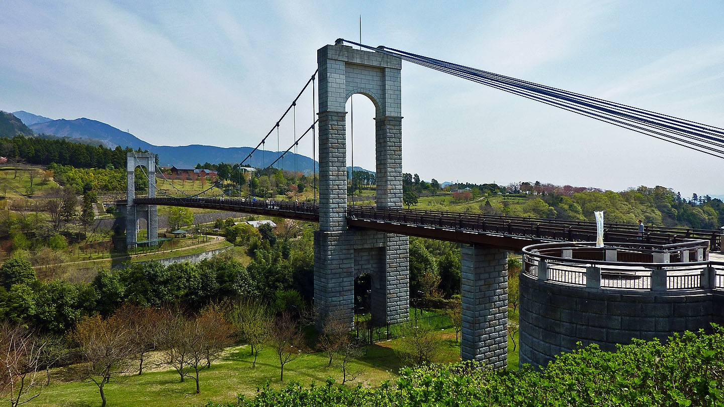
大倉 ookura okura bus stop hanano park kazenotsuribashi kaze no tsuribashi

At the Okura Bus Stop you will find a park and a bridge. Both look new. I believe the bridge, pictured above, is called Kaze no Tsuribashi (風の吊り橋). If you have time you may want to explore this area before or after the rest of your hiking. I noticed a large field of tulips just a couple minutes down the hill from this location, but it was too late to explore as I was already on the moving bus heading back to Shibusawa Station at the end of the day.

From here you want to cross the street and follow the signs to Kenmin no Mori (県民の森). You’ll be walking away from the bridge and river, not along it. Others, who were on my bus, walked along the street that runs parallel to the river. I have no idea where they were going–a different course in any event.

You’ll walk by several fields and a dozen or so homes along a sometimes curvy road for about 10 minutes. Make a left at the sign and follow that road and any signs in the opposite direction as the ones pointing to Okura (大倉). You may have to go around a fence blocking part of the trail. Follow signs towards 表丹沢県民の森.

丹沢大山国定公園

On your left you will pass the above sign. I can understand people calling a place a quasi-national park, but to put Quasi on the sign seemed a bit funny to me.

You’ll hear a river down to you left after passing this sign. Keep going for about a half hour until you see another sign with a map on it. At the map go down the steps to the right. There is a sign that probably says 黒龍の滝 or 黒竜の滝 on it pointing down. Follow it.

黒龍の滝 秦野 大蔵 丹沢

The trail splits a bit at the bottom. Follow it to the left for the above view of the Kokuryu Falls. I ate my lunch next to the waterfall. No one else was there. In fact, I only saw about 10 other hikers the entire day. This is very different than what you will experience on, say, Mt. Takao. Realize that there are tens of millions of people within an hour and half of this location and you’ll more fully appreciate what seeing only 10 people in 5 hours while moving outdoors can be like. This was on a Monday. If you go on a Saturday, or worse yet a Sunday, you’ll likely encounter more hikers.

view from kokuryu falls of tanzawa wilderness forest

Turn around at the waterfall and this is your view. Walk in this direction.

horiyamashita hatano river hike hiking near tokyo

Cross a bridge over the above river for the above scene. You’ll have a hard time believing you were in Tokyo just a couple hours before. I felt like I was back home in Oregon.

omote tanzawa kenmin forest map

You’ll see this map three or four times, at least, during the day. I took a picture of the map so I could always refer to it should I get lost. You’ll also see signs pointing you in different directions at most trail junctions. From this part of your journey (the red spot on the map marked 現在地 next to a car parking lot) always follow the paths which point to Kunugiyama (櫟山).

From the waterfall (the circled kanji in the bottom center of the above photo) you are basically doing a big clockwise loop. 櫟山 is circled on top. According to the map it is a little over an hour from the waterfall to the top of Kunugiyama. If you aren’t in decent shape, and need to rest frequently, it will take longer. You will gain hundreds of meters in elevation as you climb.

櫟山 kunugiyama

This is the toughest part of the hike. It is all uphill. However, the views are sometimes good and the trail is generally very good. For much of the time you are walking up “stairs” in the forest.

kunugizan kunugiyama nabewarizan nabewariyama sign tokyo mountain hikes maps directions

If you see this sign, a smile will cross your face as you will think your climbing is done for the day. Yeah! I made it up to the top of Mt. Kunugi, 810 meters! The views are beautiful. I can see the ocean! It’s all downhill from here, right? It has to be; I’m at the top of a mountain, right? You should then follow the sign to the right for 鍋割山方面 栗ノ木洞. At first you’ll walk down a bit. Then it is more up, up, and up. At this point I pulled up the above map on my camera. It turns out that 栗ノ木洞 (which is some kind of cave according the kanji) is actually 98 meters higher than the top of Mount Kunugi. What?!?! I always pictured mountain tops being up and caves being down. Not so here. My body wasn’t mentally prepared for this last 98 meter climb.

栗の木

But I made it. This is the sign at the cave (an invisible cave apparently as I never saw it). At this point I followed the direction for 大倉方面. This trail split and then disappeared altogether. I sort of stuck to the left. Once there was no more trail I drifted to the left until I ended up on the trail for 鍋割山. I would recommend just going with the 鍋割山 trail to begin with. The views are fantastic. You don’t need to go all the way to 鍋割山 (another mountain top). After a while the trail will split with the left fork pointing to 鍋割山 and the right fork pointing to 大倉. At this point I took the 大倉 trail and had no further problems. The forest was frequently surreal. The views were often fabulous, and there are many small streams to cross and waterfalls to view on the last hour or so before you end up where you began.

I’ll post some more photos later. Today’s entry is to give you directions more than anything else.

More from Kofu

poster for shingenko festival matsuri

My heart was filled with excitement when I reached the Kofu Station. I’m not sure if it was the fantastic weather, anticipation of the Takeda Shingen Festival, or the fact that I hadn’t been to Kofu (甲府) in almost 22 years. Probably it was mostly the latter. I was thinking that maybe my thoughts of Kofu were overblown in my head simply because it was the first place I lived in Japan, and I hadn’t been back in so long. 懐かしすぎると思って But that didn’t turn out to be the case. I wasn’t let down upon arrival. I do in fact love the place and wasn’t disappointed.

The people were friendly, the weather was spectacular, and the cherry blossoms were just past their peak. I overheard the ladies I met on the train talking quietly amongst themselves about how they should invite me to hang out with them for the festival. While this would have been fun for about an hour or two, it was barely past noon and I had lots of old, familiar territory I wanted to see again. So I said goodbye before we exited the train station and before they had a chance to continue their niceness to me. I was hoping I’d see them again later in the day, but that didn’t happen.

武田信玄像

I had made no plan of what to do once I arrived in Kofu. My first instinct on exiting the train was to see Takeda Shingen’s statue (武田信玄像) in front, which I had gazed at daily for seven months back in 1988. He looked as good as ever, especially with the cherry blossoms.

kofu city

I kept going in that direction towards my old apartment in Asahi Cho (朝日1丁). Most of the stores and buildings were different, but something felt the same too. The only stores that hadn’t changed were a doll store and a glasses store on Asahi Dori. The building I lived in was still there. It was one of the newer buildings on the street in the 1980s, I think, but now it looks like one of the oldest. Nearly everything has been rebuilt.

Before my conscious mind could catch up with my unconscious one I was in the elevator, then facing my old apartment door, and then knocking on it. No one answered which, in hindsight, was probably best. I took the above photo from the front door of my old apartment. Maybe I have a similar one from 1988 in an old photo album somewhere that I can compare it to when I get back to the U.S.

武田通り 甲府市 山梨県 武田神社 桜

I kept walking up Asahi Dori to see what else had changed, and before I knew it I was making my way to Takeda Jinja (武田神社)–again completely unplanned, my feet just started carrying me there. This brought back memories of my first night in Kofu, a cold and rainy one in January 1988 in which I rode a bike up Takeda Dori and thought the street would never end its gradual uphill climb.

This time I walked up it. Takeda Dori (武田通り) is lined with sakura (桜), but they were several days past their peak. The University of Yamanashi (山梨大学) is on this street, although I don’t remember it being located here in 1988. Was it?

I passed kids while walking up the street, and they all said hello (harro actually) to me. I really miss this in Tokyo. Kids in my neighborhood in Tokyo only say things to me if I say something to them first. Most don’t even glance at me on their way school in Nishi-Waseda. It’s as if I’m Japanese to them. Not so in Kofu.

Spring in Shinjuku

shinjuku-ku kabuki-cho signs businesses bars

Today’s picture is of the same place as the top picture in this prior blog entry, Shinjuku’s Kabukicho. The differences are the vantage point and time of day.

China’s Tokyo Embassy (The Craziest Place on Earth)

Imagine the worst DMV on the planet. Now put that DMV on steroids. And not good steroids, that make things work better, but steroids that do nothing but multiply all the things that make a trip to the DMV loathable.

The first thing you will notice at the Chinese Embassy is that you wait in line to go through security at the front door even though the security is fake. There are two security guards and a metal detector at the door. However, the metal detector goes off for more than half the people that go through it, and the guards do nothing but waive such people by. One guard asked to look through my backpack. I handed it to him. He cracked one of the three zippers and then handed it back. I could have had a gun in each of the three zippered sections (it was heavy enough as I had a book in one section and a camera in another, as well as other things), and he wouldn’t have caught them.

The place where all visas are handled is three stories high. The first level was crowded with people in various lines. I somehow figured out that I should be on the third level for my visa and was happy to leave the madness of the first level behind…

…until I got to the third level which was far worse. This 3rd floor room should never have more than about 60 people in it. On my first time there there were well over 100 people. There are lines on the 3rd floor to get numbers to get in more lines, lines to use the copy machine, lines to ask questions without a number, and more lines. People were packed in here like it was a train at rush hour. After waiting in a line of 20+ people to get a number I was told to make a copy of all of my documents. I then got in line to use the copy machine. When I got to the front of the copy machine line I found that it only takes 10 yen coins, of which I had zero. Luckily, the lady next to me gave me one. Eventually my number was called, and I was told to come back in three days to pick up my visa.

I did come back three days later as instructed, waited to get in, went through the fake security again (setting off the alarm again but was told to keep going anyway), waited in one line (Line 4) on the first floor for a while until I got close enough to the front to see the above sign, and then switched lines (to Line 6). I waited in that line only to find out that I had to go back to the third floor first. On the third floor I waited in the line to ask questions and was told to wait in the line to get a number. After waiting in the line to get a number, I waited for my number to be called. After handing over a receipt I was then told to go back to the first floor. There I waited in Line 6 where I was told to put 15,000 yen (almost $200) into a vending machine before waiting in Line 4 again. So I waited in line to put my money in a vending machine. Then I waited in Line 4 and finally received my visa to visit China.

Tokyo Marathon 2010 pictures

During the past week, by far the most popular post has been this one on the Tokyo Marathon. Maybe the weather was such that the usual number of pictures weren’t taken and people are looking for more? I have a few dozen decent shots that I’ll upload in the near future.

The one above is of the promotional poster for the 2010 Tokyo Marathon that was plastered all over the Tokyo Metro stations in the weeks leading up to the race.

The sign in the above photo asks road users to slow down. Of course it’s intended for the drivers normally on the street and not the runners. It’s kind of funny right next to the GO! GO! GO! sign.

This pack of runners must have had a celebrity in their midst, or maybe the female runner who was in the lead at the time, as there were two camera vehicles in front of them.

Iidabashi 飯田橋

The runners are coming down Sotobori Street (外堀通り) and are turning right onto Mejiro Street (目白通り).

One advantage of being 6’4″ in Japan is you can take photographs like the above.

National Foundation Day (建国記念の日)

Back on February 11 Japan celebrated National Foundation Day. Japan was supposedly founded on this day and had its first emperor obtain his position as emperor almost 2,700 years ago. This was previously a big holiday in Japan, but since WW2 it has become rather tame. We went for a walk on February 11, 2010 from Ebisu Station to Azabu Juban and then to Roppongi before getting on a train for home. Between Ebisu and Azabu Juban there were hundreds of police in riot gear, dozens of prison buses ready to haul people away, and many vans preparing for some sort of demonstration or protest. I would have taken more pictures, but it was absolutely freezing. With the wind blowing, the temperature felt well below freezing. And later in the day it snowed. Anyway, my hands had no desire to leave their gloves to take photos.

We didn’t see an actual demonstration or protest. It was so cold if such an event did take place few were witness to the proceedings. I saw nothing about it on the TV or internet either.

The truck on the left says “Restore Emperor Military” (皇軍復活). The one on the right says “Japan National Party” (日本国政党). There isn’t a political party called the Japan National Party by the way. Apparently ultra-conservative Japanese still exist, but you have to be at the right place, at the right time, to find them.