TravelJapanBlog.com - Japan (07, 09-10, 13), Denmark (08, 11, 16-19, 21, 24), Korea (13), Poland (21), Mexico (14, 15, 19, 26), Iceland (17, 19), Hawaii (14, 17, 22), Czech Republic (16, 17, 19, 21)
The above will search Traveljapanblog.com.
Concerts - Landscapes - Sports


Posts tagged panorama

Gwangan Bridge (광안대교)

광안대교 panorama photomerge gwangan beach bridge night busan korea

Panorama (photomerge) of Gwangan Beach and Gwangan Bridge at night (Busan, South Korea)

I spent last weekend in Busan on the southeast coast of South Korea. The sun never came out, and the sky was never blue during the day. However, the “blue hour” still happens even with an overcast sky.

I didn’t have a tripod and there was nothing really easy to set my camera on for a long exposure so I climbed a lifeguard tower and set my camera on the floor of the lifeguard station in order to take the photos that were photomerged together into today’s final pic.

You’ll be able to see a lot more detail in this image if you click on it while viewing it on a large screen.

May 18th Memorial Park (5.18 기념공원)

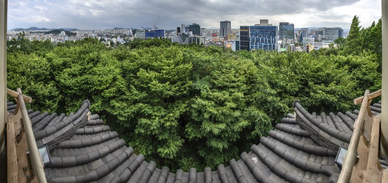
photomerge 3 story pagoda 5-18 park gwangju

View from Owolru or Owoldae Tower (오월루)

I took today’s photo (photos actually as this is a eight photo photomerge covering about 160 degrees) from the top floor (3rd floor) of a pagoda/tower in the May 18 Memorial Park in Gwangju.

When they built this tower, Owol-ru or May Observatory, more than a dozen years ago, I don’t think they thought about what would happen once the trees all grew to their full height. Right now, most of the views are obscured by trees, and that condition will only grow worse. I had to stand my 6’4″ body on the top of the top rail to see anything above the trees and take this panorama. I saw a photo in the 5.18 Memorial Culture Center (in this same park) that showed the tower with no trees around it. As things stand, if they don’t do a massive trim job on the trees soon, they will need to add another story or two to the pagoda or the views from there will be of only trees regardless of how tall you are or where you stand.

The 5.18 Memorial Culture Center shows a 12 minute or so video of the Gwangju massacre that is narrated in English. Don’t miss it if you are in Gwangju. There are also many large photos of late May 1980 in the room that I haven’t seen elsewhere.

Jikso Falls (직소폭포)

photomerge panorama jikso waterfall

Jikso waterfall

The Jikso Falls can be found inside Byeonsanbando National Park (변산반도국립공원). You can’t drive to this location. You can hike to it from two different directions. We took the shorter route (not the route from Naeso Temple) which was probably about 3 kilometers and not as steep. The waterfall can be seen in the far right portion of today’s panorama. We ate lunch right next to the waterfall even though a sign had been put up in the prior month saying you can no longer eat there or go in the falls. Our guide did not know about these new rules.

Gwangju panorama

panorama photomerge meeting of the rivers gwangju

200 degrees – Meeting of the Rivers – Gwangju, Korea

From my photos you’d think there were always blue skies in Gwangju this time of year. In reality, the skies are usually gray, but I get photo happy on the rare occasions when they are not. In the distance in the center of this photo you can see the new baseball stadium.

Hike up and over Mudeungsan and then back into Gwangju

photomerge panorama gwangju mount muduengsan

Panorama of Gwangju from the side of Mudeungsan

I did the “six hour” hike on Mt. Mudeung (무등산) a couple days ago. Today’s photo is from about an hour in. Believe it or not, after taking this photo I made it to the top of the mountain and then all the way back down into the city pictured below where I took the Gwangju Subway for the first time to get back to my bike. The hike actually took me about eight hours, but I took lots of photos along the way and got slightly lost once as well. Note if you ever plan to do this hike (especially in summer when it’s in the 80s or 90s and humid) that you can fill up your water bottles at Jangbuljae Pass. My guidebook (2010 edition of Lonely Planet Korea) says restaurant shacks can be found along the way, but they have all been cleared out since this became a National Park. In other words, bring your own food. Also note that if you ask the ranger at Jangbuljae how much farther it is to the Hakdong-Jeungsimsa Subway Station (학동·증심사입구역) and he tells you two hours, don’t believe him. Even on fresh, running legs I couldn’t have made it that far in two hours. As it was, my legs were already spent, and the last few hours were rather difficult even though it was all downhill.

Gwangju panorama

panorama gwangju photomerge

Panorama of Gwangju

This time of year in South Korea, good weather moments are few and far between. When this bit of sky looked like this last week, instead of its normal rainy-season gray, I decided I needed to find a way to the roof of my 7-story building. The doors at the top of the stairs were locked so I ended up climbing out a window and up a 20-rung-or-so ladder to reach the roof. This photo is a photomerge of many photos and covers more than 180 degrees of my view at the time. I haven’t seen more than a few minutes of blue patches in the sky since.