TravelJapanBlog.com - Japan (07, 09-10, 13), Denmark (08, 11, 16-19, 21, 24), Korea (13), Poland (21), Mexico (14, 15, 19, 26), Iceland (17, 19), Hawaii (14, 17, 22), Czech Republic (16, 17, 19, 21)
The above will search Traveljapanblog.com.
Concerts - Landscapes - Sports


Posts tagged hiking

Boundary Springs Waterfall

@BLMOregon @TravelOregon

I went back to finish what I started back in January, reach Boundary Springs. This time I didn’t start in the Mazama Viewpoint parking lot. Instead, I followed Google maps which sent me down a forest road for several miles. The road is called “Old Diamond Lake Road” or NF-281. The road gets really sketchy after a couple miles. You probably don’t want to be on this road in a normal winter. Even in summer it probably isn’t smart to take this road without 4WD. I stopped a hundred yards or so before crossing Mazama Creek as the snow started getting pretty deep. I walked from there.

After passing West Lake (which was completely frozen in the morning, but mostly not frozen when I passed it on my way back in the afternoon) I saw a trail sign for Boundary Springs. A couple hundred feet before reaching the springs I took today’s photo.

Once I got to the springs (which is where the Rogue River begins, straight out of the ground) I saw a trail of sorts on the other side of the Rogue River. I started to take it, but it soon disappeared. I don’t really like out and backs as much as loop trails so I continued (mostly bushwhacking my way north on the east side of the Rogue River) hoping the trail would appear again. Big mistake. There is no trail (that I could find) on the east side of the river. A couple hours, bloodied hands, and torn clothes later I made it back to Old Diamond Lake Road which crosses the Rogue River so I could get back to my car.

Despite the blood, it was an awesome adventure. I didn’t see a single person the entire time. In a normal winter you will definitely want snow shoes. I could have used them in several places, but for the most part I was on dry ground or only an inch or two of snow.

昇峡谷石門

 rock gate kofu shosenkyo

rock gate (sekimon or 石門) on Kofu’s Shosenkyo hike

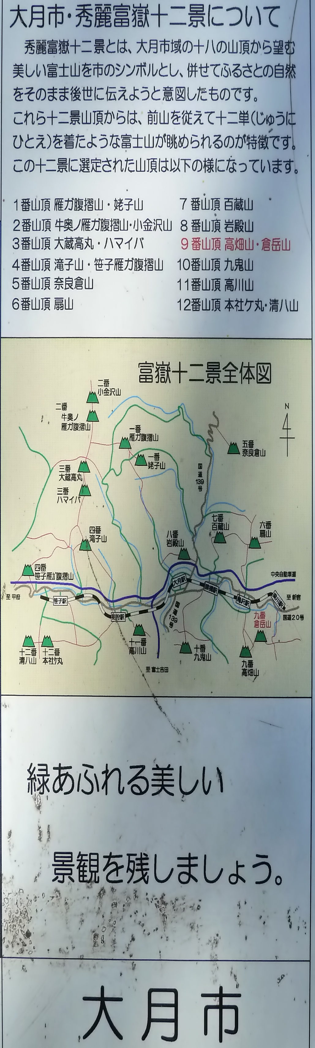
Otsuki’s 12 beautiful viewing peaks of Mt. Fuji (大月市・秀麗富嶽十二景)

otsuki kuradakesan

Otsuki City’s Kuradakesan (倉岳山)

While following one of the suggested hikes in the book “Day Walks Near Tokyo” (sadly, this was now more than five years ago) I came across the map below at the mountain top above.

otsuki city 12 beautiful peaks to view mt fuji from

map of Otsuki’s 12 peaks with beautiful views of Mt. Fuji

Apparently there are 11 other awesome hikes near Otsuki. I need to get back to Japan for some more exploring.

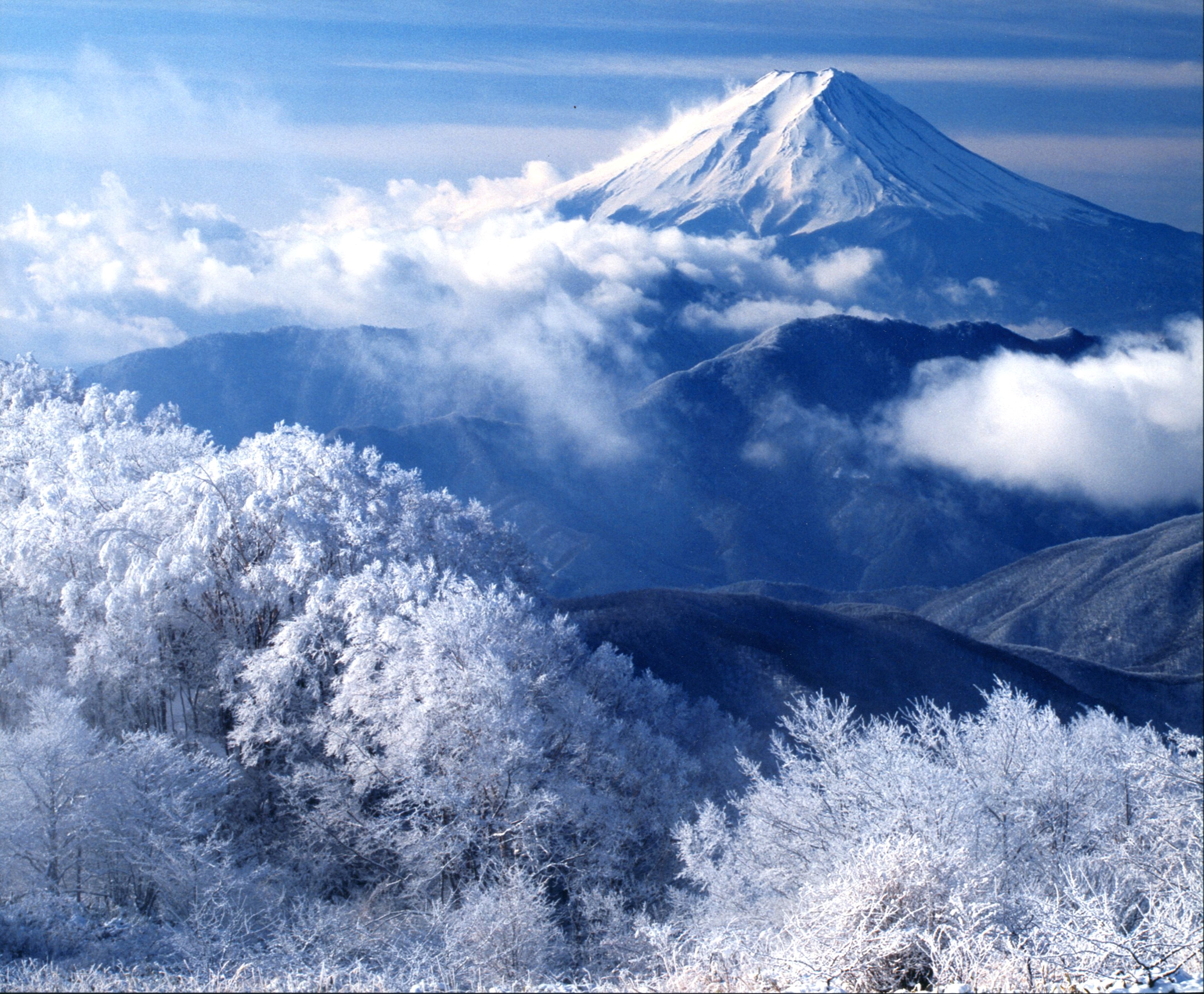
There is also a website, in Japanese, about these 12 views here. The website includes many photos from contests they’ve had over the years. Here is one of them:

Natural cement

Kilauea Iki Trail

Kilauea Iki Trail, Hawaii

At times on this trail I felt like I was on another planet or a Star Trek set.

Hiking in Kilauea Iki Crater

Hiking in Kilauea Iki Crater

Shadow portrait in the middle of the Kilauea Iki Trail (Crater National Park, Big Island, Hawaii)

We didn’t plan much on our trip to Hawaii last month, but every day was fantastic. One day we woke up and decided to drive to Crater National Park. It’s a long drive from Kona, but there were some adventures along the way. We were disappointed to learn at the park that there was no lava flow that could be observed at the time. We were told that the only lava to be seen would be the glow from the main crater of the Kilauea Volcano after the sun went down. We had hours to kill and no idea how to spend them. We asked a ranger what we could do to pass the time. She gave us a trail map and said we had just enough time to walk the Kilauea Iki Trail.

Amazingly enough, even though we hadn’t planned this hike, it ended up being one of the best hikes we’ve ever been on. You pass through lush forests, walk on smooth lava rock, and finish in a lava tube. Highly recommended.

The best time of day to do this hike in the late afternoon, counterclockwise. Not only will it be much cooler (Kona was in the 90s; this walk was in the 70s), but you will get some beautiful shadows and a sunset view beyond the crater at the end.

Hike to Rainie Falls

Rainie Falls linda ryan ellie

Rainie Falls (near Wolf Creek and Grants Pass, Oregon)

We went on a four-mile hike last week along the Rogue River. The trail is a bit harder than the four miles indicate as you are frequently walking on rocks instead of a smooth dirt path. In addition, it is rarely flat. You are usually going up or down even though the net elevation gain is minor. However, it still isn’t difficult for most people, and the view along the way and at the end (pictured above) is worth it.

If you are coming from north of Wolf Creek on I-5, take exit 76 (about 49 miles south of Roseburg). Turn left just past Wolf Creek Tavern. Follow the road for about 15 miles to Graves Creek Bridge. The trail head is on the other side of the bridge. Park on the river side, not the cliff side.

From south of Grants Pass on I-5, take exit 61. Drive to Galice Road. Turn left onto Merlin Road. Continue onto Merlin-Galice Road until it turns back into Galice Road. Park on the right before the bridge, and cross the street for the trail head.