Ashland Daily Photo
Ashland Daily Photo - A picture a day from beautiful Ashland, Southern Oregon USA in the Rogue Valley
The above will search Ashland Daily Photo.


Posts tagged biking

Eastview Trail – Ashland, Oregon

eastview trail ashland oregon mountain biking hiking southern rogue valley

The guidebooks for hiking or biking Eastview Trail talk about the wonderful views from the trail itself. Actually, there aren’t any views of the east anymore from Eastview Trail as the trees have grown since the trail was created and now the views are all obstructed. It’s still a nice trail though.

Near the trailhead, you do get a bit of a view from the location pictured here. That’s Mount McLoughlin poking up in the distance on the right.

Bend mountain biking

Ellie said her favorite part of the Paulina Plunge Tour was the last three-mile downhill stretch.

Trails by Lake of the Woods

bikes

Bikes at the Pacific Crest Trail and High Lakes Trail junction

This may be the first photo of my “new” bike I’ve posted. I’ve been riding it for several months, and it wasn’t new when I purchased this Lefty Fork Cannondale. (I take that back. There is a prior photo here, but you can’t see much of the bike in it.)

At this point on the High Lakes Trail you have your choice of continuing to Lake of the Woods (to the right) or Fish Lake (to the left). You can also head to Brown Mountain Trail (which I need to do one of these days), or you can head perpendicular to this trail to go on the Pacific Crest Trail. The possibilities of adventure are not few.

Mt. McLoughlin from High Lakes Trail

lava rocks southern oregon biking trails

Mt. McLaughlin from High Lakes Trail - Southern Oregon - Outdoor things to do in the Rogue Valley

Two thousand years ago andesite lava flows erupted from Brown Mountain near Fish Lake. Many of these rocks can still be seen along the High Lakes Trail. I like the change in scenery while riding a bike along this trail; one minute you are in a forest and the next you are cruising through single track with lava rocks on both sides of you.

Fish Lake

fish lake jackson county oregon

Fish Lake - Jackson County - Southern Oregon

If you are going round trip on the Lake of the Woods to Fish Lake trail (High Lakes Trail, about 15 miles round trip) then it doesn’t matter which lake you begin and end at in terms of difficulty. However, if you want to take it easy and are only going one way then the route from Lake of the Woods to Fish Lake, pictured above, is a bit easier since Fish Lake is a few hundred feet lower in elevation than Lake of the Woods. There is a bit of a summit in the lava rocks between the two so regardless of which lake you begin at you will be going mostly uphill initially and mostly downhill as you approach the other lake.

High Lakes Trail No. 6200

trail signs

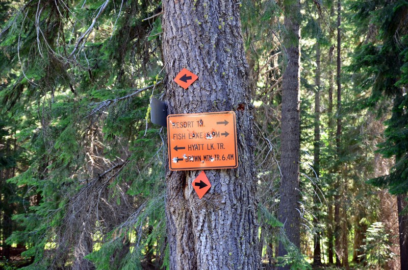
Parking place for High Lakes Trail

This past week we went on a little family outing to the east of Ashland. We have done the trail from Lake of the Woods to Fish Lake before, but this was the first time we all made it for the entire round trip.

To avoid paying the $7 day-use fee by parking at one of the lakes, we parked at the sign pictured above which is approximately where the A is on the map below.

trail connecting lake of the woods and fish lake southern oregon

Biking trail map for Lake of the Woods

At this point we made a mistake and went to the right since the sign says Fish Lake is to the right. This does not put you on the High Lakes Trail (which is what you want if you are hiking or biking). Instead, it puts you on the Resort Trail which looks like an old car trail. The Resort Trail is anything but resort-like, and it eventually disappears, but not before you have to carry your bike over lots of fallen trees and ride over other rather difficult terrain. To avoid this pitfall, keep going down the road (to the left toward Brown Mountain Trail) in the top photo a bit (maybe 20 yards) and then hang a right on High Lakes Trail.

More photos and info to come in the next week…

Caterpillar Trail

caterpillar trail mountain bike riding siskiyou mountains ashland oregonsiskiyou mountains bike racingcaterpillar trail ashland watershed

Back on father’s day I was trying out my 24mm prime lens while on a bike ride up in the Siskiyous. As luck would have it, just as I got my D7000 out of the bag to take a photo of the Caterpillar Trail sign, a few riders came down so I got to test out the responsiveness in low light.

For the first rider I had the dial in the “Auto-No Flash” mode and didn’t have time to change it. Needless to say he blurred a bit as they were coming down the trail fast. That first shot was taken with a shutter speed of 1/160, ISO200, f6.3. I had a few seconds to adjust for the second guy pictured above. I quickly spun the dial over to Scene and then moved the scene to “sports.” I then fired off the above three shots in rapid succession. The camera fired at 1/1000 with an ISO of 500 and f4. I was pleased with the result of three well focused, sharp images (in poor light even), with a frozen rider in each.

BMX track in Ashland

Yours truly showing the kids a thing or two (not really) at the BMX track near the dog park in Ashland.

BMX track at end of Bear Creek Greenway in Ashland

I went for a little bike ride yesterday on the Bear Creek Greenway. Someone is in the process of building a BMX track at the Ashland end of the bike path near the Ashland Dog Park.

A couple of boys were admiring my new (to me, it’s actually used) lefty fork Cannondale so I started chatting with them. I took a few pictures of the boys on the BMX track and sent the pics to them via email after they texted me their email addresses. They were quite happy with the photos.

Ashland School Closures (or not)

We have more snow today than yesterday on the roads, and it is several degrees colder. But yesterday school was cancelled and today the Ashland School District will be in session. My kids are disappointed.