More Britt Festival photos (Aimee Mann)
I’m heading to another show at Britt tonight (Cheap Trick), but I’m not bringing my camera. Today I can offer you a couple more pics from last week’s excellent Aimee Mann show though.

| The above will search Ashland Daily Photo. |
I’m heading to another show at Britt tonight (Cheap Trick), but I’m not bringing my camera. Today I can offer you a couple more pics from last week’s excellent Aimee Mann show though.
I have posted quite a few photos with Mt. Ashland in the background. Today’s pic is a little different as I took it last night while walking to the top of Mt. Ashland while looking south (into California mostly). The mountainside was covered in wild flowers. I couldn’t see all of the mountain ranges in the distance a few minutes before with the bright, summer sun. But as soon as the sun began to set, everything came into focus. It was that magical 10 minutes of the day that happens only at dawn or dusk.
Today’s photo is more than a couple years old. I’m excited to head back up Grizzly Peak soon to see how the trees are doing now that additional time has passed since the East Antelope Fire of 2003.
After the news from yesterday’s entry, we got in the car and drove back to Fish Lake in order to obtain those longed-for malts and shakes. Here we are perched on the deck of the Fish Lake Resort waiting for our orders with Fish Lake in the background. Thus ends this series on the trail between Lake of the Woods and Fish Lake.
We were hoping for a malt or shake at the restaurant at Lake of the Woods but were informed that we’d have to go back to Fish Lake in order to get such a thing as the closest thing they had on their menu was a root beer float.
At the end of our bike ride we found ourselves back at Lake of the Woods.
This may be the first photo of my “new” bike I’ve posted. I’ve been riding it for several months, and it wasn’t new when I purchased this Lefty Fork Cannondale. (I take that back. There is a prior photo here, but you can’t see much of the bike in it.)
At this point on the High Lakes Trail you have your choice of continuing to Lake of the Woods (to the right) or Fish Lake (to the left). You can also head to Brown Mountain Trail (which I need to do one of these days), or you can head perpendicular to this trail to go on the Pacific Crest Trail. The possibilities of adventure are not few.
Two thousand years ago andesite lava flows erupted from Brown Mountain near Fish Lake. Many of these rocks can still be seen along the High Lakes Trail. I like the change in scenery while riding a bike along this trail; one minute you are in a forest and the next you are cruising through single track with lava rocks on both sides of you.
If you are going round trip on the Lake of the Woods to Fish Lake trail (High Lakes Trail, about 15 miles round trip) then it doesn’t matter which lake you begin and end at in terms of difficulty. However, if you want to take it easy and are only going one way then the route from Lake of the Woods to Fish Lake, pictured above, is a bit easier since Fish Lake is a few hundred feet lower in elevation than Lake of the Woods. There is a bit of a summit in the lava rocks between the two so regardless of which lake you begin at you will be going mostly uphill initially and mostly downhill as you approach the other lake.
This past week we went on a little family outing to the east of Ashland. We have done the trail from Lake of the Woods to Fish Lake before, but this was the first time we all made it for the entire round trip.
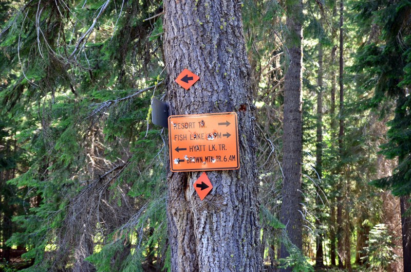
To avoid paying the $7 day-use fee by parking at one of the lakes, we parked at the sign pictured above which is approximately where the A is on the map below.
At this point we made a mistake and went to the right since the sign says Fish Lake is to the right. This does not put you on the High Lakes Trail (which is what you want if you are hiking or biking). Instead, it puts you on the Resort Trail which looks like an old car trail. The Resort Trail is anything but resort-like, and it eventually disappears, but not before you have to carry your bike over lots of fallen trees and ride over other rather difficult terrain. To avoid this pitfall, keep going down the road (to the left toward Brown Mountain Trail) in the top photo a bit (maybe 20 yards) and then hang a right on High Lakes Trail.
More photos and info to come in the next week…