Ashland Daily Photo
Ashland Daily Photo - A picture a day from beautiful Ashland, Southern Oregon USA in the Rogue Valley
The above will search Ashland Daily Photo.


Archive for nature

Hobart Peak

Ellie Ryan Hobart Peak southern oregon pct hiking pacific crest trail ashland oregon

Ellie & Ryan on Hobart Peak looking north toward Emigrant Lake and Ashland

After living in Ashland for nearly 14 years, I thought I had been on every nearby hike. Turns out I was wrong. Hobart Peak (AKA Hobart Bluff) is more of a walk than a hike as it isn’t long (about 3 miles round trip) and only has a bit of elevation gain near the end. The sky was completely blue on the day we went. I want to go again for a sunrise or sunset or between storms.

If you are in Ashland and want to check it out, get on Highway 66 toward the Green Springs. After a little less than 15 miles from Oak Tree Northwest Bar & Grill, turn right onto Soda Mountain Road. In about 3.5 miles park at the trail marker near a meadow. You’ll be on the Pacific Crest Trail (PCT) initially. A sign a mile in will direct you to the left to get to the location in today’s photo.

My first (not entirely successful) focus stack

This past weekend I was hiking on Upper Table Rock. The ground was covered with wildflowers and snow-covered Mt. McLoughlin looked splendid in the distance. So I took this photo of the wildflowers.
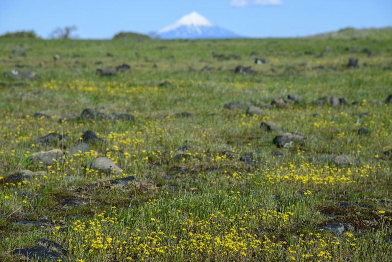
foreground focus

foreground focus

But I wanted a photo with Mount McLoughlin in focus so I took another one.

distant focus

distant focus

When I got home I was a bit disappointed in each photo.

My photography and Photoshop skills are completely self taught. I have never taken a class, had a tutor/mentor, or even read a book on either subject. I’ve learned merely by trial and error with my camera and trying different things in Photoshop.

So what I wanted to do was combine the above two photos. I did so by using Photomerge (under File/Automate) in Photoshop and unchecking the “Blend Images Together” option. Hit F7 to see the layers if your layers box isn’t already open. Select both images, and use Auto-Blend Layers (under Edit) to stack the images. The result is below.
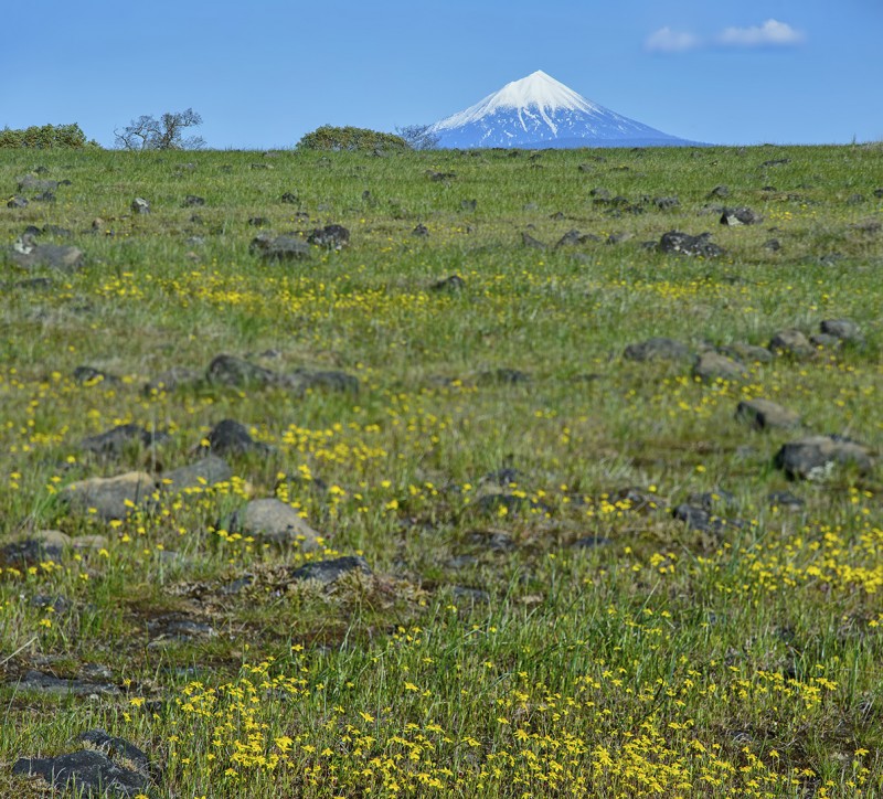
photomerge focus stack upper table rock mt mclaughlin

Photomerged focus stack

It’s not perfect, but now I have a new option at my fingertips in the future. Two things I need to do differently:
1) Take more than two photos. Notice how the finished result is out of focus in the middle. Had I taken three or four photos, each with a different focus point, the entire stacked photo could have been in focus.
2) Maintain the same, or nearly the same, composition (and camera settings–shutter speed, ISO, aperture). I recomposed the scene a bit after taking the first image which doesn’t make for the best stacking conditions later in post.

A more recent focus stack of a similar scene can now be found here.

Almost Spring Break

curt bacon golfing mark siders house

driving golf balls off an Ashland deck

Temperatures are, on average, warmer. Students are restless. Spring Break is just over a week away. We’ll start a bit early with a party this Friday. What are you doing for Spring Break?

(That’s Pilot Rock, just left of center in the distance, in today’s photo from last fall’s SOU School of Business party. Look really closely, maybe after clicking on the photo for a higher resolution version, and you can see the golf ball in flight.)

Don’t blink or you’ll miss it

ashland sunrise

Ashland sunrise

Several days ago the sky looked rather bland as I got out of the shower. A minute later it looked like this so I took a quick photo. Within 30 seconds it looked like nothing special again.

East Ashland from Dead Indian Memorial Road

dead indian memorial road

View from Dead Indian Memorial Road

Flying over Shasta Lake

flying over lake shasta aerial view photography airplane northern california

flying over Lake Shasta

Diamond Woods

diamond woods golf course oregon monroe trees moss

Mossy trees in Monroe, Oregon

I went for a walk this past Sunday morning when we were staying at the Inn at Diamond Woods, a place on a golf course between Eugene and Corvallis. The grass was mostly flooded from the rain the day before so there weren’t many golfers.

The sun had barely peeked through the clouds when I took today’s photo. Rain began again soon thereafter which was fine by us since we were going to be indoors all the rest of the day at the CEVA Presidents’ Day Volleyball Tournament.

Ashland horses

horses ashland field

Backyard Olympics

male deer rack fight battle territory

Fog in the valley below

ashland fog in the valley below

Ashland in the fog

I took today’s photo more for the hundreds of birds that were streaking across the sky than for the fog, but the photo didn’t look like it featured birds. Instead, it looked like I had small specs of dirt all over my lens so I photoshopped the specs out and left only the bird on the top of the tree in the bottom portion of the photo, two trees left of center.